Last Updated:December 19, 2025, 14:34 IST
The map is a controversial idea that shows an expanded version of Bangladesh including parts of India.

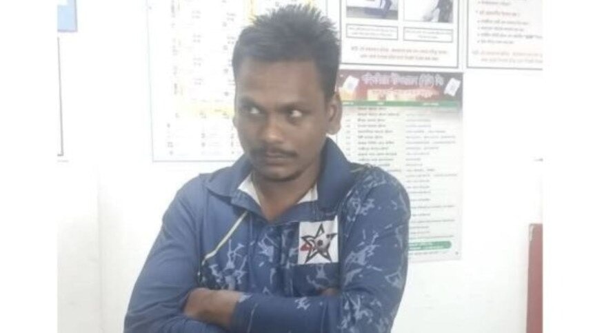
Bangladesh saw overnight violence after youth leader Sharif Osman Hadi, who was shot during an election campaign, died on Thursday while being treated in a hospital in Singapore. He reportedly circulated maps of the so-called “Greater Bangladesh” that showed several Indian territories as part of the nation.

Hadi, 32, died on December 18. He was shot in the head last week by masked attackers while he was launching his election campaign in Dhaka’s Bijoynagar. Doctors in Dhaka said his condition was extremely critical, so the interim government led by Muhammad Yunus flew him to Singapore in an air ambulance. He died after six days.

Osman Hadi rose to prominence during Bangladesh’s 2024 student uprising, which eventually led to the ouster of Sheikh Hasina. He later became a spokesperson for the Inquilab Mancha platform and contested the general elections as an independent candidate. Hadi was known for sharp political rhetoric and an aggressive public style. (Photo: AP)

After news of his death spread, large crowds gathered in Dhaka and other cities, demanding the arrest of those behind the attack. Some reportedly turned to arson and vandalism. Authorities said buildings housing media offices like The Daily Star and Prothom Alo were set on fire, trapping staff inside. In Rajshahi, protesters reportedly used a bulldozer to demolish a local office of the Awami League, former PM Sheikh Hasina’s party. (Photo: Reuters)

The Greater Bangladesh Map: “Greater Bangladesh” refers to a controversial socio-political concept that imagines an expanded Bangladesh including parts of neighbouring India and Myanmar. Maps linked to this idea have appeared on social media and at exhibitions. The idea is linked to nationalist thinking and draws from historical kingdoms like the Bengal Sultanate or Pala Dynasty. It has triggered diplomatic concerns, especially for India. (Photo Credits: X)
 State, as part of a so-called “Greater Bangladesh”.")
According to several reports, Hadi allegedly circulated or displayed such maps online. These depictions showed large swathes of eastern and northeastern India, including Bihar, Jharkhand, Odisha, West Bengal and the entire Northeast, along with Myanmar’s Arakan (Rakhine) State, as part of a so-called “Greater Bangladesh”.

This map, titled “Sultanate-e-Bangla”, was shown at a Dhaka University Pohela Baishakh exhibition in April earlier this year.

The idea behind the controversy goes back to the final years of British rule. In 1947, leaders such as Sarat Chandra Bose, brother of Shubhash Chandra Bose, and Muslim League leader Huseyn Shaheed Suhrawardy suggested a united and independent Bengal, separate from both India and Pakistan. This proposal was called the ‘Sarat Formula’ or ‘Bengal Pact’. It got initial support from Gandhi and Jinnah but failed after facing strong opposition from Congress and League high commands.

A “Greater Bangladesh” map created in 2018 by Rabbir Hossain Bhuyain showed these expanded borders. Today's claims loosely refer to this history but go much further. History says Bose never supported taking Indian territory to expand Bangladesh. (Photo: Wikipedia)

The Bangladeshi government has not officially supported the “Greater Bangladesh” idea. Authorities have also said the investigation into Hadi’s killing has no link to any territorial or foreign policy issue.
News Photogallery viral What Is ‘Greater Bangladesh’ Map? Explained Amid Violence In Dhaka After Anti-India Leader Osman Hadi's Death