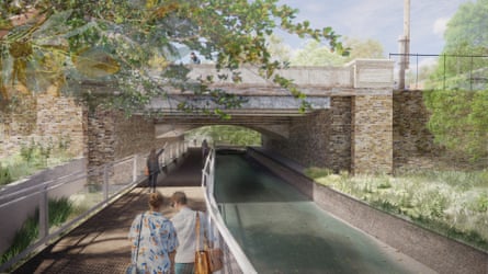
A 6km bicycle and pedestrian path that will run along a 100-year-old rail corridor and connect two of Sydney’s most popular waterside walks is set to open later this year.
The Minns government said on Friday that the GreenWay – stretching north from the Cooks River in Earlwood through the inner west to the Bay Run on Parramatta River at Iron Cove – was 80% complete.
The $60m project will intersect with the south-west Metro line due to be completed in 2026.
The NSW premier, Chris Minns, said both projects would “revolutionise transport” in the city’s inner west and unite communities that previously lacked connections via walking, cycling or public transport.
“This project is confined to inner west, but if you link up these two sections … you’ll see a transformation in the way a lot of Sydneysiders interact with the inner west, the Canterbury region, and then all the way into the city,” Minns said on Friday.
“We think this pathway will be a major tourism draw, not just for locals who live in Sydney but also for people from around the world. It’s something extra to do in this great city, and the government’s been very clear in our intention to have more urban consolidation [and] more density.”
Sign up for Guardian Australia’s breaking news email
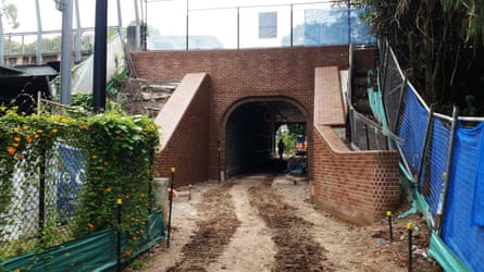
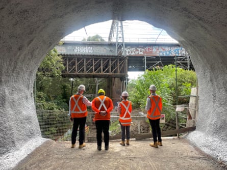
The project mostly follows the route of the inner west light rail and Hawthorne Canal and has required the construction of underpasses and tunnels beneath major roads to create continuous paths.
The Hercules parklands and the New Canterbury Road underpass are the final sections to be completed.
Local MP Jo Haylen said the “active transport” corridor connected the Cooks River in the south to the harbour in the north. The GreenWay would allow people to access the Metro at Dulwich Hill station.
GreenWay mapThe finished project will feature parks and foreshores, playgrounds, sporting facilities, bushcare sites, public art, cafes and cultural and historical sites.
The Minns government’s housing policy has focused on increasing the density of housing stock around urban centres and transport.
Minns said on Friday that required a “world’s best practice” approach to achieve “the kind of density and liveability that you’ve seen in places like Brooklyn and London and Barcelona and Paris”.
skip past newsletter promotionafter newsletter promotion
“There’s absolutely no reason why we can’t have people living in tight communities with world-class public transport, great access to bike lanes, wonderful, beautiful, open parks, enjoying the most beautiful city in the world,” he said.
The original idea for the GreenWay came from community advocates in the inner west.
The Inner West council mayor, Darcy Byrne, said it had been a 20-year vision of the local community. He said the “incredibly exciting” project would transform the way people moved.
“We know that kids will use the GreenWay to get to school, either walking or on their bikes, that families will use it recreationally, and it’s also going to be a centre of public art,” he said.
“We’re investing in 10 major public artworks right along the length of the GreenWay, which will make this a place that people from all over Sydney want to come and visit.”
Darcy added: “Later … the Metro will open and there will be very fast rail running every four minutes. That is going to be truly transformative. It will get people out of their cars and on to their scooters and bikes and walking more as well.”